


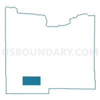
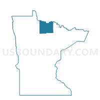
Evergreen Unorg. Voting District, Koochiching County, Minnesota
About
Outline

Summary
| Unique Area Identifier | 602807 |
| Name | Evergreen Unorg. Voting District |
| County | Koochiching County |
| State | Minnesota |
| Area (square miles) | 69.98 |
| Land Area (square miles) | 69.59 |
| Water Area (square miles) | 0.40 |
| % of Land Area | 99.43 |
| % of Water Area | 0.57 |
| Latitude of the Internal Point | 47.96572120 |
| Longtitude of the Internal Point | -94.02413350 |
Maps

Graphs
Select a template below for downloading or customizing gragh for Evergreen Unorg. Voting District, Koochiching County, Minnesota


Neighbors
Neighoring Voting District (by Name) Neighboring Voting District on the Map
- Dinner Creek Unorg. Voting District, Koochiching County, MN
- Englewood-Pinetop Precinct, Koochiching County, MN
- Forest Grove Precinct, Koochiching County, MN
- West Koochiching Voting District, Koochiching County, MN
- Wildwood-Plumcreek-Steffe Precinct, Koochiching County, MN
Top 10 Neighboring County Subdivision (by Population) Neighboring County Subdivision on the Map
- Northwest Koochiching UT, Koochiching County, MN (463)
- Northome UT, Koochiching County, MN (447)
- South Koochiching UT, Koochiching County, MN (189)